


Le Pradet la Garonne la Mine

giovannoni
User
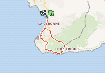

Length
5.2 km

Max alt
113 m

Uphill gradient
146 m
Km-Effort
7.2 km

Min alt
0 m

Downhill gradient
145 m
Boucle
Yes
Creation date :
2025-03-24 07:36:47.547
Updated on :
2025-03-24 07:36:49.927
1h37
Difficulty : Medium

FREE GPS app for hiking
 SityTrail
IGN / Geographical institutes
SityTrail Plus
The world is yours!
About
Trail Walking of 5.2 km to be discovered at Provence-Alpes-Côte d'Azur, Var, Le Pradet. This trail is proposed by giovannoni.
Positioning
Country:
France
Region :
Provence-Alpes-Côte d'Azur
Department/Province :
Var
Municipality :
Le Pradet
Location:
Unknown
Start:(Dec)
Start:(UTM)
257847 ; 4775425 (32T) N.
Comments